Planning your trip
Getting to the Murchison GeoRegion
The Murchison GeoRegion is approximately 600km north of Perth or 400km east of Geraldton in Western Australia.
Planning your trip and being prepared is essential as, while shops and services are available in the towns, travel time and distances between remote areas can be long.
There is a lot of great advice out there and we’ve compiled some for you here as well.
If you need help, advice or directions on your travels, phone or call into the local Visitor Information Centres in Cue, Meekatharra, Mount Magnet, Murchison, Sandstone, Wiluna and Yalgoo, and remember to download a copy of the Murchison GeoRegion Trail Guide or the free app to help plan your trip before you leave.

Food and fuel are generally available every 100–300km in the Murchison GeoRegion. When travelling in remote locations, we suggest you carry enough food and water for your travel party to last at least 48 hours.
The Murchison GeoRegion Trail Guide has a comprehensive list of accommodation, food and fuel stops in each town.
While camping is available at some geosites, not all sites allow overnight visitors.
You’ll find camping areas, caravan parks and station stays suitable for you and your travel companions throughout the region. Contact local Visitor Information Centres to find out more.
Important notes:
- Take your rubbish with you and do not litter
- Observe fire restrictions as dry conditions means fire can spread very quickly – speak to the local Visitor Information Centre if you are unsure of the restrictions
- Lock up your valuables
- Leave nothing but your footprints
There are no fees required to visit geosites in the Murchison GeoRegion, however, some sites require a permit or permission for access. Visitation to some geosites is also restricted due to cultural, conservation or safety reasons.
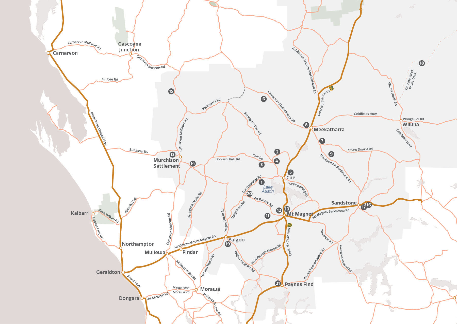
Visit our Maps page for the full list of sites and to download the app for full details of what is allowed at each site.
The brilliant starry night skies and ancient rock formations of the Murchison GeoRegion will captivate you on the ROCKS STARS roadtrip with 14 locations identified by Astrotourism WA for stargazing at night, along with places to visit during the day and geosites to explore.
You’ll find more information on the Astrotourism WA website.
The Mulga Shrublands of the Murchison GeoRegion are renowned for spectacular wildflowers, diverse plants and unique native fauna.
Many interesting species of native plants and animals can be found a short distance off the road or at local reserves. Staff at local Visitor Information Centres will be happy to point you in the right direction for the best local spots!
Keep a look out for the Desert Kurrajong, carpets of everlastings, the unique wreath flower (leschenaultia macrantha), bright orange wild pomegranate, native foxgloves, orchids, grevillia, acacia, blue cornflowers, mulla mulla and flannel bush, to name a few.
As you travel around, look out for the incredible array of wildlife in the region, some of which are very rare. You’ll see eagles, hawks, parrots, honeyeaters, emus, kangaroos, skinks, goannas and bungarras. And keep an eye out for the elusive pebble-mimic dragon lizard and echidna!
Please be aware that mobile phone coverage in the Murchison GeoRegion is limited outside of towns. Telstra is the leading service provider in very remote locations, and some providers have no coverage.
We encourage you to download the Murchison GeoRegion app to your phone before travelling so that you have offline access to regional information. More info on the app is available here.
Due to cultural, conservation and/or safety reasons, some of the Murchison GeoRegion sites are not accessible without permission. These sites have been included in the trail due to their significance.
Although you cannot visit, local Visitor Information Centres will be able to provide you with more information and how to seek permission for access.
Road conditions in the outback can change relatively quickly depending on the weather. Therefore, please familiarise yourself with the road conditions on your route before you set off each day. Most of the sites in the Murchison GeoRegion are accessible for all vehicles; however, some are more suited to 4WD.
Check road conditions with the local Shires or Visitor Information Centres before travelling as the condition of unsealed roads varies according to weather, usage and grading.
As a visitor, we ask that you pay respect to the environment, the land, the sites and the cultural values of the places you visit.
- Please follow the directions on signage at sites.
- Please do not touch, disturb, pick up or remove cultural materials, such as artefacts, artworks, rocks or shells.
- Please do not remove or damage any flora or fauna and leave rocks and dirt undisturbed.
- Please do not use fallen trees etc., for campfires. These provide housing for small animals (bring your firewood with you).
- Be respectful of the natural environment. Take your rubbish with you and avoid disturbing the ground by sticking to established tracks.
You can learn more and help preserve important places by reading the booklet of the Aboriginal Cultural Sites and Artefacts by the Yamatji Marlpa Aboriginal Corporation.
Station Stays offer a truly unique and authentic outback experience. Accommodation ranges from luxury rooms in station homesteads to workers’ quarters and campsites. Station Stays in the Murchison GeoRegion have excellent access to towns, attractions, geo sites and unlimited night skies.
The Murchison GeoRegion Trail Guide includes a list of Station Stays in the region.
Cue Visitor Centre
Austin St, Cue
(08) 9963 1198
Meekatharra Visitor Centre
Main St, Meekatharra
(08) 9980 1811
Mount Magnet Visitor Centre
Hepburn St (Great Northern Highway), Mount Magnet
(08) 9963 4172
Murchison Oasis Roadhouse and Caravan Park
Carnarvon–Mullewa Rd, Murchison
(08) 9961 3875
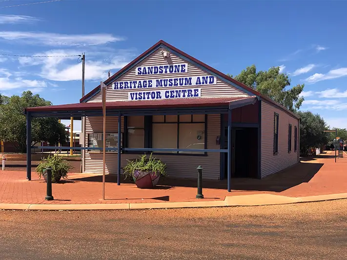
Sandstone Heritage Museum and Visitor Centre
Corner of Oroya & Hack St, Sandstone
(08) 9963 5061
Canning–Gunbarrel Discovery Centre
Scotia St, Wiluna
(08) 9981 8009
Yalgoo Visitor Information
Gibbons Street, Yalgoo
(08) 9962 8042
The climate in the Murchison sub-region is semi-arid to arid, with hot summers and mild winters. Temperatures are highest between November and March. The region is known for hot, dry days with average inland temperatures exceeding 40°C.
April to October is the best time to visit the Murchison, with mild days and cool to cold nights. Temperatures range from 20–33°C during the day and 6–17°C at night. The winter months have the highest number of rainy days, which livens flora and fauna to create a spring bursting with colour.
Please note: Some sites and access roads may close due to extreme weather events, so please plan ahead and check with local Visitor Information Centres.
While you are here...
Call into the local Visitor Information Centres in Cue, Meekatharra, Mount Magnet, Murchison, Sandstone, Wiluna and Yalgoo to find out more about the Murchison GeoRegion, local attractions and things to see and do in the area.
You can also pick up a copy of the Murchison GeoRegion Trail Guide and Map to take on your travels. Click below to learn more about the towns in the area.